During today's ramblings, I found a sharecropper's shack and took a few pictures of it. But the camera's in the car, and I am supremely lazy, so I made some maps (thank you, Google Earth!) of where I ride. Perhaps those of you playing at home can keep up with my vague country descriptions better now.
Here is a pretty little aerial photo of my horses' pasture. Keep that lake in mind; it'll help orient you later.

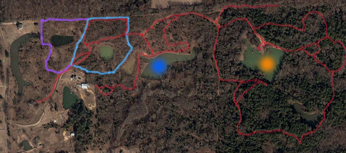
Click any of these pics for the bigger version if you'd like. In this next picture, the purple outline is the back field, but the fence is down there so the horses aren't roaming back there right now. The baby blue outline is the paddock - there's a gate between the main field and the paddock, and another gate which is usually open leading back to the rest of the fields. The red lines represent most of the trails - some of them are as nice as anything you'd find in a top-notch state park; some of them are actually just deer trails that I use.
The blue dot lake has some good fishing. The orange dot lake is where those redneck kids go skeet shooting - they set up the skeet machine at the north edge of the lake and shoot from the south end. There's a levee on the ESE side of the skeet lake, but a large tree has partially fallen on the levee and blocked that trail. If you want to circle the skeet lake, you have to go waaaay to the SE around the little hidden lake.
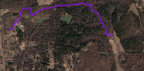
This map shows how I went wandering on Tuesday and found that deer hunting field. The purple line is my path out to the deer field; the orange dot is the tree stand. There's two houses visible in the picture - east of the deer stand and NNE of the stand. I rode close enough to the houses to realize they were in fact houses then turned around. Google Earth says it's about a 4 or 5 mile roundtrip.
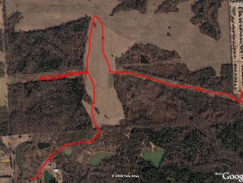
Here's today's ride. T has been buggin me to go explore the big soybean field, so that's exactly what we did. The cut through the woods where our red line went west and east is a power line easement - we went west first, but there's an unbridged ditch. The ditch would've been easy enough to jump... except the ground was very spongy and none of us (horses included) know how to jump. We could have just galloped the horses at the lil baby ditch and tried to redneck foxhunt our way over it, but I actually do try to be a responsible adult when I'm out with the minor T. (Also, I don't want to get catapulted off of my horse onto my head in muddy water, but shhhhh - let's blame it on the kid being with me!)
After we were stymied to the west, we headed to the northernmost point you can see and investigated a mysterious white thing. It looked like a barrel; it was, in fact, a barrel. Then we headed back and detoured to the east down the power lines.
The sharecropper shack is in the woods, right off the power line clearing, about halfway down. Pictures tomorrow, I promise.
We rode all the way to the subdivision and snuck our horses all the way up to the paved road. Then we turned around and snuck right back out - we didn't want to talk to anybody, just explore a little!
After we got back, I rode Dixie. I'll write a separate post about that - perhaps one day I can look back on the Dixie posts and actually see some logical improvement in our work together!
I need a redneck dictionary. What's a skeet? What's a sharecropper?
ReplyDeleteLove the Google earth addition to the blog. Lots of little ponds/lakes where you are.
ptierane = adjective describing a 16-tiered wedding cake
Pffft, you Canadians!
ReplyDeleteI'll have you know that skeet shooting is an official Olympic sport. There's a machine that slings bright orange 4" clay disks into the air, and you shoot the disks out of the air. It's like ... practice for shooting birds. Or an excuse to go shoot!
I'll put up the sharecropper shack pictures and write a whole post about them. It's pretty rough. :(